Illustration
Map description
- Title
- Homisland WIO
- Description
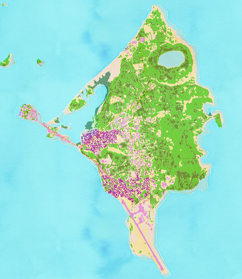
- This cartographic platform presents a homogeneous land use product on the small islands of the western Indian Ocean.
These object-oriented remote sensing products were developed from SPOT 5 images fused at 2.5 meters resolution provided by the SEAS-OI station. Other data were used to improve the quality of land use: the main roads of the OpenStreetMap database, the zoning of agricultural areas where available and the SRTM DTM.
The land uses of Reunion Island, Mayotte and Mahé (Seychelles) were designed by Christophe Révillion (IRD/UMR ESPACE-DEV) as part of the Lept-OI project (FEDER POCT 31569) and the ISSE-Mayotte project (Ministère de l'Outre-Mer 2013/2015).
The land use of the islands of the Union of the Comoros was carried out by Artadji Attoumane as part of a Master2 TRN project (UMR CMAEE and UMR ESPACE-DEV) and a doctoral thesis at the University of La Réunion funded by the IRD (ARTS Scholarship).
The data can be downloaded in zip format by clicking on the link in front of the layer in the legend (i). A metadata sheet in XML format is contained in the download zip. The data will be regularly completed and updated.
This portal is based on the online map publishing solution LizMap and was implemented by Christophe Révillion.
Reference : Christophe Révillion, Artadji Attoumane, Vincent Herbreteau. A free high resolution land cover on the small Indian Ocean islands, an example of its use with the study of vector-borne diseases. ISRSE37, May 2017, Tshwane, South Africa.
To reuse these data, please quote: Land cover produced by the UMR Espace-Dev, available at http://homisland.seas-oi.org/
Properties
- Projection
- EPSG:4326
- Extent
- 27.38601503819599259, -30.98546700586449631, 70.39749584619598011, 1.55203648721906617
Contact
- Organization
- IRD, Université de La Réunion
- Person
- Christophe Révillion, Artadji Attoumane, Vincent Herbreteau
- christophe.revillion (at) univ-reunion.fr vincent.herbreteau (at) ird.fr
- Phone
Hide information
